Cedar Creek and Cub Creek 2 Closures Being Revised With Some Campgrounds, Trails and Roads Reopening
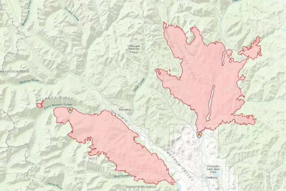
Trail and road closures, put into place after last summer’s Cedar Creek and Cub Creek 2 fires on the Methow Valley Ranger District, have been lifted or revised. Some closures will remain in effect until conditions stabilize, which could be a year or more in some cases because of an increased risk of debris flow from runoff and weather events, and concern for additional damage to trail treads or road surfaces.
“We are continuing to mitigate the fire related hazards and to open additional roads and facilities,” said Methow Valley District Ranger Chris Furr. “Over the next couple months, crews will continue to assess trail damage and work to re-open sections where it is safe and feasible to do so. People should expect to encounter road construction equipment accessing the closed roads in the Cub Creek 2 fire area as repairs to culverts, drivable dips, and the roadbed occur.”
Several roads and trails are closed due to the substantial number of danger trees. “Extending the closure on these roads and trails to June of 2023, will allow for completion of hazard tree felling and also allow time for soil to recover,” said Furr. “We anticipate the closure area will be reduced as that work is completed.”
Trails included in this closure order are in severely burned areas and pose a resource and safety risk because of their high density and more intensive use by recreationists traveling at greater speeds on mountain bikes, which increases potential for additional erosion to fragile post-fire soils.
“We need your help and cooperation,” Furr said. “Please comply with the closures as this will enable crews to work safely and efficiently while also reducing further damage to the trails. As areas reopen, visitors should not assume that all hazards are gone. Public lands are inherently ‘use at your own risk,’ but we want to make sure everyone has the information they need to make informed decisions to manage their own risk.”
Cub Creek 2 Fire Area:
- Falls Creek, Chewuch, and Camp 4 campgrounds are now open. Buck Lake and Nice Campgrounds, located up Eightmile Creek, will remain closed because of fire related danger trees either in or adjacent to the campground, and/or along access roads.
- Other campgrounds up Eightmile Creek (Flat, Ruffed Grouse, and Honeymoon) were re-opened last fall. Campers should be aware that post-fire debris flows are still a possibility, especially during heavy rain events, and should move camp if need be.
- Trails to Falls Creek Falls, First Butte, and Eightmile Ridge are all now open. There are no remaining trail closures within the Cub Creek fire perimeter.
- All dispersed campsites between the main Chewuch Road (Road #51) and the road up the east Chewuch (Road #5010) are now open for the public to use at their own risk.
- Several roads within the Falls Creek, Bromas Creek, Leroy Creek, Junior Creek, Brevicomis Creek, and Sherwood Forest/Buck Lake areas will remain closed at this time due to the excessive amount of burned trees and/or the potential for debris flows.
Cedar Creek Fire Area:
- All trail and road access up Cedar Creek, Wolf Creek, and Driveway Butte is now open.
- The Cedar Creek Trail has been cleared of downed trees to the falls. Trail tread repair work is underway in the Wolf Creek area. Trailhead facilities at Wolf Creek, including the toilet and corral, burned during the fire and have not yet been repaired or replaced.
- In the Chickadee area, all trails are open except the following trails (12 miles total):
- Aqua Loop Trail (Nordic)
- Thompson Ridge Trail from its southern terminus on FS Road 4410000 to 2.4 miles from its northern terminus
- Upper Climb It Change Trail
- Woodpecker Trail from the junction with Meadowlark Trail, located in T34N R21E S19, to its junction with Wild Turkey Trail located in T34N R21E S19
These trails remain closed due to high burn severity in combination with hazard trees, tread damage, and the potential for excessive damage to fragile post-fire soils in this high use area.
Press release provided by the U.S. Forest Service
More From NewsRadio 560 KPQ


