Major Evacuation Orders Issued As Labor Mountain Fire Escalates
The Labor Mountain Fire made a significant push on Saturday, prompting a LEVEL 3 (GO NOW) evacuation on Mission Creek Road south of Sand Creek.
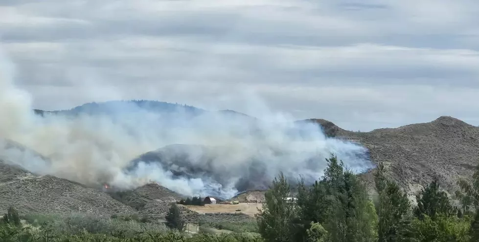
The fire has swelled to 33,318 acres with 7% containment.
The evacuation orders as of Sunday morning.
- Level 3 (Get out now!), Mission Creek Road south of Sand Creek
- Level 3 (Get out now!), US 97, milepost 163.5 to 174
- Level 3 (get out now!) has been added to Camas Creek Road above and including 2955 and Camas Way.
- Level 3 (Get out now!): Ingalls Creek Rd. and all of Valley Hi.
- Level 2 (Be prepared to leave): A portion of Old Blewett Road and Camas Creek Road, including Niles Lane.
- Level 1 Fire Advisory (Be alert): Brender Canyon Road, from Sky Meadows Road to the end. All of Sky Meadows Road, all of Brisky Canyon Road, and Mission Creek Road from Tripp Canyon Road to the end
An emergency shelter is open at Christ Center Church, 5800 Kimber Road in Cashmere. Anyone needing assistance with domestic or large/livestock animal care due to the current fires should call Animal Care & Control Dispatch at 509-888-7283.Tillicum Riders is accepting large animals and livestock at the Chelan County Fairgrounds & Expo Center in Cashmere.

The Labor Mountain Fire spread to the north and east towards Mission Creek and Road 71 on Saturday and was active in the Beverly Creek area towards Ingalls Creek, where crews are installing a 2.5-mile hose lay. Structure protection is focused on Blewett Pass, Camas Land, Camas Road, Blewett Road, and Valley Hi.

On Sunday, the Incident Management Team is incorporating drones to assess the fire and, in some cases, ignite backfires. Hot Shot crews are fighting the fire directly where conditions are safe on 7204 Road. Dozer crews are also working in the area east of Highway 97, where the fire spread in recent days.
The smoky conditions will persist because of an inversion and light winds but an increasing chance of rain through Thursday. UNHEALTHY to even HAZARDOUS air quality is possible in Entiat, Wenatchee and locations to the south
along the Columbia River.
There are no changes to evacuation orders already in place through Saturday, when a LEVEL 3 (GO NOW) order was posted for Mission Creek near Cashmere.
The Labor Mountain fire was lightning-caused and started September 1st. 10 miles north of Cle Elum. The fire is burning timber and brush. 21 crews, 17 engines, 13 helicopters, 4 bulldozers, and 15 water tenders are deployed on the fire with over 600 personnel and several hundred additional firefighters from the Sugarloaf Fire providing support.
The fire is about 8 miles southeast of Cashmere, WA.

The Lower Sugarloaf Fire is burning less than 5 miles to the north of Cashmere.
There are no changes to the current evacuation orders;
Level 3 Evacuation (Get out now!)
- Area on the west side of Entiat River Road, from Dinkelman Canyon Road up to the intersection with Crum Canyon Road. (Only the west side of Entiat River Road)
- Nahahum Canyon Road, from end of pavement to top, as well as Warner Canyon
- Swakane Canyon Road, from 97A to the top
- Burch Mountain Road, from the dirt section and up the mountain
Level 2 Evacuation (Be Prepared)
- Crum Canyon Road down to Dinkelman Canyon (east side of Entiat River Road)
- Entiat River Road, from Dinkelman Canyon Road to just past Mills Canyon Road (west side of Entiat River Road)
- Upper Sunnyslope in Wenatchee, including West Mountain Brook and Avalon Lane, East Mountain Brook, Pheasant Canyon Court, Burch Hollow Lane and Lone Ram Lane
Level 1 Fire Advisory (Be Alert)
- Sunnyslope area: Area north of Easy Street, from Sunnyslope to Monitor
- Eagle Creek Road to Spring Canyon (just past Hay Canyon Road)
- Entiat River Road, from Mills Canyon Road downriver to 97-A.
- Upper portions of Crum Canyon Road and Byers Canyon Road
The Lower Sugarloaf blaze showed minimal growth on Saturday at the southern section near Burch Mountain and Swakane Canyon on Saturday. Dozer lines were strengthened in the Roaring Creek area near Entiat. Structure protection was mostly in the Entiat Valley and Cashmere. Low visibility hampered the air support
On Sunday, crews are working on direct attack on the edge of the fire and any spot fires in Roaring Creek and Swakane Canyon. There is work planned for strengthening all containment lines and strategic backfires where needed. The air support will be limited until Sunday afternoon, if possible, due to the inversion and low visibility.
The Lower Sugarloaf fire is 38,459 acres with 32% containment since it was sparked by lightning on September 1st, 12 miles northeast of Leavenworth. There are 1,780 people assigned to the incident with 43 crews, 131 engines, 13 helicopters, 8 dozers, and a fleet of 45 water tenders transporting water around the fire zone.
There is a 10 percent chance of wetting rain this evening on both the Labor Mountain and Lower Sugarloaf fires.
The Okanogan-Wenatchee National Forest has closed all areas in the vicinity of both fires for the safety of firefighters and the public. US Hwy 97 remains closed over Blewett Pass. Evacuation orders from the Chelan County Emergency Management at Levels 1, 2, and 3 remain in place.
The latest evacuation orders from Chelan County Emergency Management HERE
More From NewsRadio 560 KPQ